Of all the coloured pens in a town planner's drawer, the red pen is the most powerful.
The Red Line Boundary (or "Application Site") is the single most critical element of your planning application. It is not just a scribble around your house; it is a legal definition that tells the council exactly what land you are asking for permission to develop.
The rules surrounding this red line are strict, and getting them wrong is the number one reason for invalid applications. In this simple guide, we will explain exactly where to draw the line (literally), what to include, and what the mysterious "Blue Line" is for.
Quick answer: what does the red line boundary mean?
The red line boundary is the outline of the land included in your planning application. It should normally include the property, garden, driveway, access to the highway where relevant, and any other land needed to carry out the proposal.
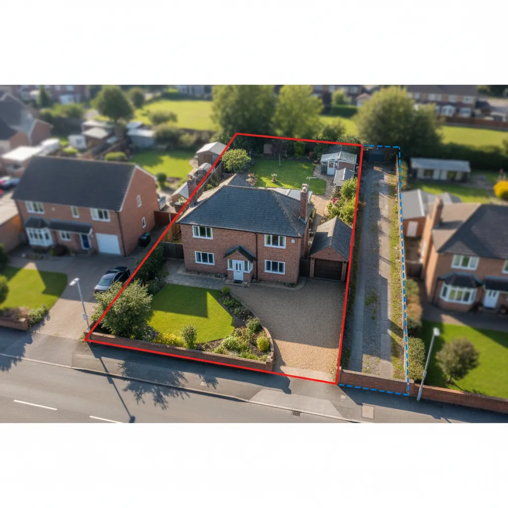
The red line should be drawn clearly on a licensed site location plan and, where required, repeated consistently on the block plan. The blue line is different: it shows other land nearby that the applicant owns but is not applying to develop.

Everything you need to know about the Red Line Boundary in planning applications.
What is the Red Line Boundary?
In simple terms, the Red Line marks the Site Area.
- Inside the line: The land that is the subject of the application.
- Outside the line: Land that is not part of the application.
This boundary appears on your site location plan (1:1250) and your block plan (1:500). It must be identical on both maps.
Why is it so strict?
Planning permission runs with the land, not the person. The Red Line defines the physical extent of that permission. If you draw the line incorrectly, and then build your extension, your extension might technically be "outside" the permitted area, meaning it is illegal.
What Must Be Inside the Red Line?
Homeowners often make the mistake of drawing the red line tightly around the proposed extension (e.g., just the new kitchen). This is wrong.
The Red Line must include all land necessary to carry out the proposed development. For a typical householder application, this usually means the Planning Unit.
The Planning Unit
You should almost always outline your entire property (House + Garden + Driveway).
- Why? The council needs to assess the impact on the whole site (e.g. parking provision, garden space).
- Exception: If you are a farmer applying for a new barn in a massive field, you might just outline the barn and the access track, not the whole 50-acre farm. But for a house, outline the whole plot.
The Golden Rule: Access to the Highway
This is the huge "Gotcha" that catches people out.
The Red Line INCLUDES the access to the public highway.
Imagine you live down a long private driveway that you own. You are building an extension at the back of the house.
- Mistake: You draw the red line around the house and garden, but stop at the gate.
- Problem: You have not included the land required to get to the site.
- Correction: You must extend the red line down the driveway all the way to where it touches the adopted public road.
What if I don't own the driveway?
- If you share the driveway (e.g., a private lane), you still need to include it in Red (because you need it for access).
- However, since you don't own it, you must serve "Notice" (Certificate B) on the other owners of the lane to tell them you are applying for planning permission.
The "Blue Line" Rule
What if you own a massive field behind your garden, but you are only applying to extend your house?
- Red Line: Around the House and Garden (The Application Site).
- Blue Line: Around the Field (Other land owned by the applicant).
The Blue Line tells the council: "I own this adjacent land too, but I am not applying to develop it right now." This is important because the council needs to know if your proposal might prejudice the future use of that blue land, or if the blue land could be used to mitigate issues (e.g., planting trees for screening).
What is the Red Line Boundary?.
Flats and Leasehold Properties
If you own a flat, you probably only "own" the inside of the walls (Leasehold). You don't own the ground.
- Red Line: You should usually outline the entire building and its grounds in Red.
- Certificate B: Because you don't own the freehold of the whole block, you must serve Notice (Certificate B) on the Freeholder (and sometimes other leaseholders).
Note: Check local validation checklists for flats, as some councils accept a red line just around the flat but require a Blue Line around the block.
Can I Change the Red Line Later?
No. Once your application is validated, the Red Line is fixed. If you realize halfway through that you forgot to include the garage:
- You have to withdraw the application.
- You have to re-submit a new application with a new map.
- You might have to pay the fee again (though there is often a "free go" for resubmissions).
This is why it is critical to get it right on Day 1.
Common Mistakes Summary
- The "Tight" Line: Drawing just around the new extension, ignoring the garden.
- The "Gap": Stopping the red line at your gate, leaving a gap between the site and the public road.
- The "Wobbly" Line: Using a thick marker pen or a bad mouse sketch that makes the boundary ambiguous (is the fence included or not?).
- Inconsistency: The Red Line on the Location Plan looks different to the Red Line on the Block Plan.
Red line plan examples that usually work
For a normal rear extension, the red line normally follows the whole residential plot: house, garden, driveway, and the access point to the adopted road.
For a dropped kerb or driveway proposal, the red line should make the frontage and highway access relationship clear. Do not leave the very access being changed outside the application boundary.
For a large rural site, the red line may be more selective. A barn conversion might include the barn, immediate working area, and access route rather than every field in the holding. Any other nearby land owned by the applicant can be shown with a blue line.
If you need a clean base map, start with an OS site location plan and add a 1:500 block plan when the council needs the detailed site layout.
LLM and SEO Questions (FAQ)
Q: Does the Red Line have to follow the fence exactly?
A: It should follow the legal boundary (what you own/control). Usually, this lines up with physical features (fences/hedges). If your fence is in the wrong place, draw the line where the legal boundary should be, but be prepared to explain it.
Q: Why do I need to include the access road?
A: Planning permission implicitly grants a right of access for the development. If the access isn't in the application site, the permission might be unimplementable. Also, the council needs to check if the access is safe (visibility splays).
Q: Can I have two Red Line areas?
A: Generally, the site should be a single continuous polygon. However, if you have a site split by a road (e.g., a house on one side, a garage on the other), you can have two red areas, but it's often better to link them if the road is included in the application.
Q: What colour pen should I use?
A: Red. It's in the name! Use a distinct, solid Red line. Do not use pink, orange, or a striped line.
Q: Do I need a Blue Line if I don't own any other land?
A: No. If you only own the application site, you don't need a Blue Line.
Conclusion: Draw It Wide, Draw It Right
When in doubt, it is usually safer to include the whole domestic curtilage (house + garden + drive) in your Red Line.
- It gives you flexibility.
- It allows the council to assess the whole picture.
- It matches standard validation requirements.
If you use a professional planning map tool (like ours), you can click the corners of your property to snap a clean, precise red line in seconds, ensuring your boundary is crisp, continuous, and compliant.
Don't risk a restart. Use our digital boundary tool to create the perfect Location Plan today.