Red Line Boundary Rule Explained
A practical guide to drawing the red-line boundary correctly on planning maps.

1:1250 OS Planning Map
Generate compliant 1:200, 1:500, 1:1250, 1:2500, 1:5000 & 1:10000 planning maps instantly. Available in PDF, DWG & DXF formats. Trusted by architects, developers, and homeowners.
Already purchased? View your orders
|
See what customers say
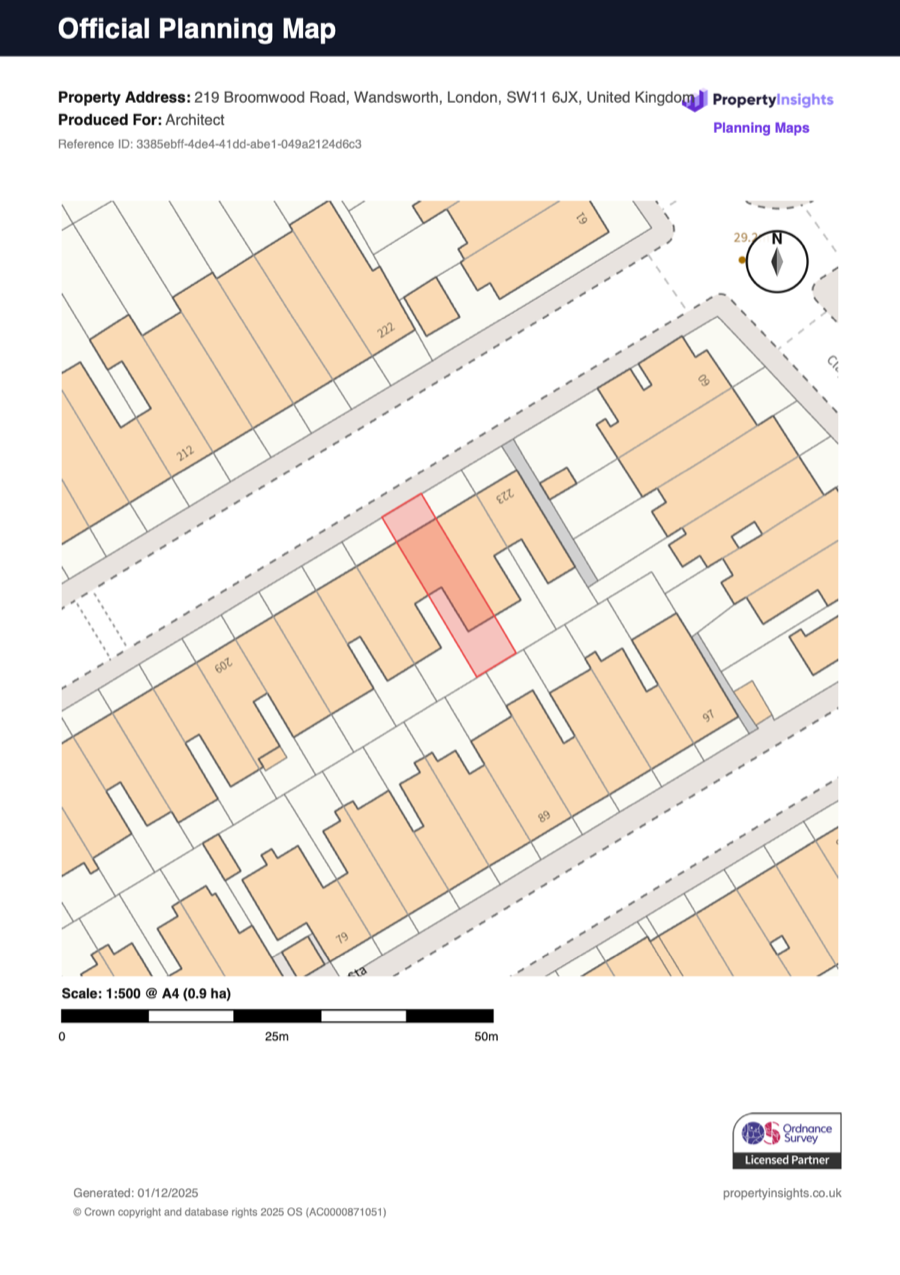
Loading map...
Search an address to begin
By clicking "Buy & download now", you agree to our terms, refund and corrections policy.
Search an address to begin
By clicking "Buy & download now", you agree to our terms, refund and corrections policy.
Create an OS-compliant 1:1250 site location plan online for planning permission, lawful development certificates, and other council submissions. Pair it with a 1:500 block plan when the council also needs local site detail, or upgrade to CAD output for design workflows.
Search, preview, and download your planning maps in under 60 seconds. No waiting for quotes.
Our workflow checks your location plans for planning applications against standard planning-map presentation requirements.
Why do councils reject maps? Usually, it's one of these three reasons. We handle them all automatically.
Your site location plan must show the application site edged clearly in a red line. This includes all land necessary to carry out the development (access, gardens, etc.). If you own other land nearby, it must be edged in blue. Our tool lets you draw both effortlessly.
"About right" isn't good enough. You need specific scales: 1:1250 for location plans and 1:500 for block plans. Crucially, every map must clearly show a North point. We automatically generate compliant maps for planning permission with correct scales and orientation.
Screenshots from Google Maps are copyright infringement and will be rejected instantly. You must use licensed Ordnance Survey planning maps. Our plans come with a valid license number clearly displayed, proving to the council you have the right to use the data.
Choose the right scale, paper size, and printed-copy option for your project. All plans are OS MasterMap® accredited.
| Map Type | Scale | Coverage | Area | Price |
|---|---|---|---|---|
| Site Plan | 1:200 | 35m x 35m | 0.12 ha | £7.95 |
| Block Plan | 1:500 | 90m x 90m | 0.81 ha | £12.95 |
| Location Plan | 1:1250 | 141m x 141m | 2 ha | £19.95 |
| Location Plan | 1:1250 | 225m x 225m | 5.1 ha | £39.95 |
| Rural / Estate Plan | 1:2500 | 316m x 316m | 10 ha | £49.95 |
| Rural / Estate Plan | 1:2500 | 387m x 387m | 15 ha | £54.95 |
| Rural / Estate Plan | 1:2500 | 450m x 450m | 20 ha | £59.95 |
| Large Scale Location Plan | 1:5000 | 707m x 707m | 50 ha | £109.95 |
| Large Scale Location Plan | 1:5000 | 866m x 866m | 75 ha | £149.95 |
| Large Scale Location Plan | 1:5000 | 894m x 894m | 80 ha | £212.95 |
| Regional Context Plan | 1:10000 | 1789m x 1789m | 320 ha | £374.95 |
| Map Type | Scale | Coverage | Area | Price |
|---|---|---|---|---|
| Site Plan | 1:200 | 50m x 22m | 0.11 ha | £7.95 |
| Block Plan | 1:500 | 125m x 57m | 0.71 ha | £12.95 |
| Location Plan | 1:1250 | 200m x 120m | 2.4 ha | £19.95 |
| Location Plan | 1:1250 | 312m x 143m | 4.5 ha | £39.95 |
| Rural / Estate Plan | 1:2500 | 625m x 285m | 17.8 ha | £59.95 |
| Large Scale Location Plan | 1:5000 | 1340m x 570m | 76 ha | £254.95 |
| Regional Context Plan | 1:10000 | 2680m x 1140m | 306 ha | £440.95 |
| Map Type | Scale | Coverage | Area | Price |
|---|---|---|---|---|
| Site Plan | 1:200 | 50m x 50m | 0.25 ha | £18.95 |
| Block Plan | 1:500 | 127m x 127m | 1.6 ha | £24.95 |
| Location Plan | 1:1250 | 316m x 316m | 10 ha | £49.95 |
| Location Plan | 1:1250 | 335m x 335m | 11.2 ha | £74.95 |
| Rural / Estate Plan | 1:2500 | 500m x 500m | 25 ha | £99.95 |
| Large Scale Location Plan | 1:5000 | 707m x 707m | 50 ha | £129.95 |
| Large Scale Location Plan | 1:5000 | 866m x 866m | 75 ha | £169.95 |
| Large Scale Location Plan | 1:5000 | 1000m x 1000m | 100 ha | £199.95 |
| Large Scale Location Plan | 1:5000 | 1225m x 1225m | 150 ha | £239.95 |
| Large Scale Location Plan | 1:5000 | 1323m x 1323m | 175 ha | £269.95 |
| Large Scale Location Plan | 1:5000 | 1342m x 1342m | 180 ha | £281.95 |
| Regional Context Plan | 1:10000 | 2683m x 2683m | 720 ha | £525.95 |
| Map Type | Scale | Coverage | Area | Price |
|---|---|---|---|---|
| Site Plan | 1:200 | 76m x 40m | 0.30 ha | £18.95 |
| Block Plan | 1:500 | 190m x 100m | 1.9 ha | £24.95 |
| Location Plan | 1:1250 | 400m x 250m | 10 ha | £49.95 |
| Location Plan | 1:1250 | 475m x 250m | 11.9 ha | £74.95 |
| Rural / Estate Plan | 1:2500 | 625m x 400m | 25 ha | £99.95 |
| Large Scale Location Plan | 1:5000 | 1950m x 1000m | 195 ha | £320.95 |
| Regional Context Plan | 1:10000 | 3900m x 2000m | 780 ha | £645.95 |
| Map Type | Scale | Coverage | Area | Price |
|---|---|---|---|---|
| Block Plan | 1:500 | 200m x 200m | 4 ha | £39.00 |
| Location Plan | 1:1250 | 316m x 316m | 10 ha | £79.00 |
| Location Plan | 1:1250 | 500m x 500m | 25 ha | £129.00 |
| Rural / Estate Plan | 1:2500 | 707m x 707m | 50 ha | £149.00 |
| Rural / Estate Plan | 1:2500 | 866m x 866m | 75 ha | £159.00 |
| Rural / Estate Plan | 1:2500 | 1000m x 1000m | 100 ha | £169.00 |
| Large Scale Location Plan | 1:5000 | 1225m x 1225m | 150 ha | £199.00 |
| Large Scale Location Plan | 1:5000 | 1414m x 1414m | 200 ha | £219.00 |
| Large Scale Location Plan | 1:5000 | 1581m x 1581m | 250 ha | £239.00 |
| Map Type | Scale | Coverage | Area | Price |
|---|---|---|---|---|
| Block Plan | 1:500 | 250m x 160m | 4 ha | £39.00 |
| Location Plan | 1:1250 | 400m x 250m | 10 ha | £79.00 |
| Location Plan | 1:1250 | 625m x 400m | 25 ha | £129.00 |
| Rural / Estate Plan | 1:2500 | 1000m x 500m | 50 ha | £149.00 |
| Rural / Estate Plan | 1:2500 | 1250m x 600m | 75 ha | £159.00 |
| Rural / Estate Plan | 1:2500 | 1250m x 800m | 100 ha | £169.00 |
| Large Scale Location Plan | 1:5000 | 1500m x 1000m | 150 ha | £199.00 |
| Large Scale Location Plan | 1:5000 | 2000m x 1000m | 200 ha | £219.00 |
| Large Scale Location Plan | 1:5000 | 2500m x 1000m | 250 ha | £239.00 |
| Map Type | Scale | Coverage | Area | Price |
|---|---|---|---|---|
| Block Plan | 1:500 | 283m x 283m | 8 ha | £49.00 |
| Location Plan | 1:1250 | 707m x 707m | 50 ha | £149.00 |
| Rural / Estate Plan | 1:2500 | 866m x 866m | 75 ha | £179.00 |
| Rural / Estate Plan | 1:2500 | 1225m x 1225m | 150 ha | £209.00 |
| Rural / Estate Plan | 1:2500 | 1414m x 1414m | 200 ha | £229.00 |
| Large Scale Location Plan | 1:5000 | 1581m x 1581m | 250 ha | £259.00 |
| Large Scale Location Plan | 1:5000 | 2236m x 2236m | 500 ha | £329.00 |
| Map Type | Scale | Coverage | Area | Price |
|---|---|---|---|---|
| Block Plan | 1:500 | 400m x 200m | 8 ha | £49.00 |
| Location Plan | 1:1250 | 1000m x 500m | 50 ha | £149.00 |
| Rural / Estate Plan | 1:2500 | 1250m x 600m | 75 ha | £179.00 |
| Rural / Estate Plan | 1:2500 | 1500m x 1000m | 150 ha | £209.00 |
| Rural / Estate Plan | 1:2500 | 2000m x 1000m | 200 ha | £229.00 |
| Large Scale Location Plan | 1:5000 | 2500m x 1000m | 250 ha | £259.00 |
| Large Scale Location Plan | 1:5000 | 4000m x 1250m | 500 ha | £329.00 |
| Option | Paper Size | Copies | Notes | Price |
|---|---|---|---|---|
| Printed Copy Pack | A4 | 5 colour copies | Single-plan add-on posted to your address | £10.00 |
| Printed Copy Pack | A3 | 5 colour copies | Single-plan add-on posted to your address | £15.00 |
| Bundle Print Pack | A4 | 6 colour copies | Bundle add-on with 3 copies of each plan | £10.00 |
| Option | Term | Includes | Excludes | Price |
|---|---|---|---|---|
| Single PDF Plan Protect | 12 months | Boundary and annotation edits, plan name / produced-for changes, map-view tweaks up to 10%, and PDF re-downloads | No CAD, no new scales, no new paper sizes | £4.95 |
| Bundle Plan Protect | 12 months | One Protect purchase covers all PDF plans in the bundle, plus re-downloads during the active term | No CAD, no new scales, no new paper sizes | £8.95 |
| Map Type | Recommended Plot Scale | Coverage | Area | Price |
|---|---|---|---|---|
| Site Plan | 1:200 | ~32m × 32m | 0.1 ha | £14.95 |
| Site Plan | 1:200 | ~50m × 50m | 0.25 ha | £22.95 |
| Block Plan | 1:500 | ~90m × 90m | 0.81 ha | £29.95 |
| Block Plan | 1:500 | ~130m × 130m | 1.7 ha | £39.95 |
| Location Plan | 1:1250 | ~173m × 173m | 3 ha | £59.95 |
| Location Plan | 1:1250 | ~224m × 224m | 5 ha | £67.95 |
| Location Plan | 1:1250 | ~316m × 316m | 10 ha | £129.95 |
| Rural / Estate Plan | 1:2500 | ~447m × 447m | 20 ha | £235.95 |
| Rural / Estate Plan | 1:2500 | ~500m × 500m | 25 ha | £239.95 |
| Large Scale Location Plan | 1:5000 | ~707m × 707m | 50 ha | £339.95 |
| Large Scale Location Plan | 1:5000 | ~1000m × 1000m | 100 ha | £451.95 |
| Regional Context Plan | 1:10000 | ~1225m × 1225m | 150 ha | £563.95 |
| Regional Context Plan | 1:10000 | ~1414m × 1414m | 200 ha | £610.95 |
Includes both DWG and DXF formats. CAD files are supplied in real coordinates, so the scale shown here is a plotting guide rather than a fixed paper-output constraint.
Planning Guides
A practical guide to drawing the red-line boundary correctly on planning maps.
Learn what a site location plan must show, which scale to use, and when councils require one.
See what free map tools can and cannot provide before ordering a planning-ready location plan.
Use a site location plan to show where the land sits in its wider setting. Add a block plan when the council also needs a detailed 1:500 site layout around the proposal.
Choose this when you need a 1:1250 location plan for planning permission, prior approval, or a lawful development certificate. It shows the site in relation to nearby roads and surrounding plots.
Create 1:1250 site location planChoose this when you also need a 1:500 site plan showing boundaries, access, buildings, and the detailed layout around your proposal footprint.
Create 1:500 block planLocal authorities reject up to 30% of applications due to map errors. Our system automatically enforces these 6 critical requirements.
The application site must be edged clearly with a continuous red line. This defines the legal boundary of the development.
Every map must clearly indicate North. Ours are automatically oriented and marked.
Maps must be scalable. We include a precise graphical scale bar (e.g. 0-50m) on every PDF.
At least two street names must be clearly visible.
Always at the required metric scale.
Valid license number printed on every plan.
Trusted by architects & homeowners
Free correction if PlanningMapsUK causes a map-preparation issue.
Perfect for homeowners managing their own Permitted Development applications, extensions, annexes, or dropped kerbs.
Download a 1:500 Block Plan to show your new driveway or garden layout clearly.
Get the standard 1:1250 Location Plan required for every single application.
Just select your property, check the preview, and get a ready-to-print PDF instantly.
"The easiest part of my whole planning application." — Sarah, Bristol
Stop tracing PDF maps. Get professional, layered OS MasterMap® CAD data instantly. Integrate directly into your AutoCAD, Revit, or SketchUp workflow.
If a planning authority flags a PlanningMapsUK map-preparation or compliance fault, we will review it and correct the affected map free of charge.
If the issue is caused by our map output:
Most planning applications require both.
1. A Site Location Plan (usually 1:1250) to show where the property is located in the neighborhood.
2. A Block Plan (usually 1:500) to show details like boundaries, driveways, and the proposed works.
Check with your local planning authority or architect, but ordering one of each is the safest bet to avoid validation delays.
Planning authorities generally require maps to be created within the last 12-18 months. Using an old map runs the risk of rejection if new developments (like a neighbor's extension) aren't shown. Our maps are generated live from the latest Ordnance Survey database, ensuring they are always up to date.
Generally, no. Planning authorities require up-to-date mapping with a valid license. Many people search for an "ordnance survey map of my house" hoping to use an old deed or screenshot, but planning requires current OS MasterMap® data. Using unlicensed or outdated maps is the #1 reason for application invalidation.
The map shows the underlying Ordnance Survey topography (fences, walls, buildings). You must then add the "Red Line" to indicate your specific application boundary. Our easy-to-use tool lets you draw this red boundary (and any blue land-ownership boundaries) directly onto the map before downloading.
You will instantly receive your plans in PDF format (perfect for emailing to councils or printing). We also offer CAD formats (DWG & DXF) for architects and design professionals, allowing for easy editing in AutoCAD and other software.
Reply to your order email and let us know what needs changing. Customer-input redraws are normally handled as a paid correction or a new order unless we choose to waive the fee.
Yes, usually. Even for Permitted Development, you typically need to apply for a Lawful Development Certificate to prove the work was legal. This application requires the same compliant Site Location Plan as a full planning application.
We use OS MasterMap® Topography Layer, which is the most detailed and accurate mapping dataset available in Great Britain. It shows individual buildings, correct footprints, fences, paths, hydration features, and road names.
Join thousands of architects and homeowners who use our tool for licensed planning maps with correction support where the fault is ours.
Internal Linking Hub
You May Also Need
Create a 1:500 block plan or site plan showing buildings, access, boundaries, and proposal detail.
Buy block planBuy Ordnance Survey planning maps online, including site location plans and block plans for council-ready submissions.
Buy OS planning mapsDownload editable Ordnance Survey CAD planning maps in DWG and DXF for architects, surveyors, and consultants.
View CAD planning maps