
CAD and GIS · 25 May 2026
GeoPackage, SHP and GML: GIS Map Formats Now Available on PlanningMapsUK
PlanningMapsUK now offers OS MasterMap CAD and GIS exports, including GeoPackage, SHP ZIP and GML for professional planning workflows.
Read guidePlanningMapsUK Blog
Detailed guidance on site location plans, block plans, large scale Ordnance Survey mapping, and the common mistakes that slow down planning applications.
Use This Hub To Choose The Right Plan
Whether you need a site location plan for planning permission, a block plan, or larger Ordnance Survey mapping, this page brings together the guides most likely to answer the question before you order.
The articles below cover Planning Portal requirements, scale choices, rural and larger-site mapping, validation failures, and the differences between maps, drawings, and full submission packs.
Featured Guides
These guides target the questions we see most often around planning permission maps, Planning Portal submissions, and buying the correct OS plan first time.
CAD and GIS · 25 May 2026
PlanningMapsUK now offers OS MasterMap CAD and GIS exports, including GeoPackage, SHP ZIP and GML for professional planning workflows.
Read guide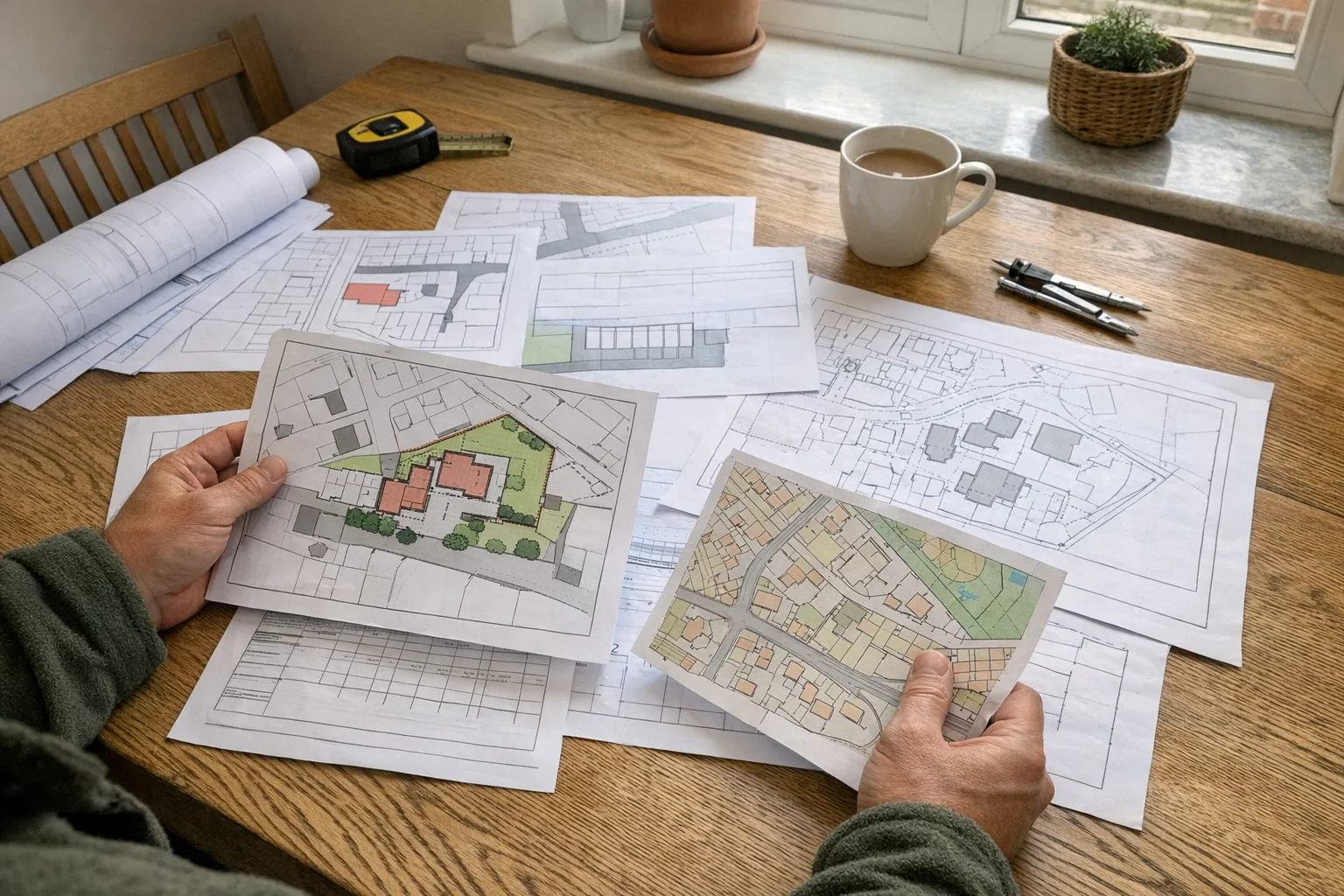
Planning Maps UK · 26 Apr 2026
A practical guide to planning maps for builders, including location plans, block plans, CAD maps, client handover, quotes, and council submissions.
Read guide
Residential Projects · 25 Apr 2026
Applying for a dropped kerb or driveway access? Learn which planning maps you may need, how to mark the red line, and what councils look for.
Read guideAll Guides
Practical articles for homeowners, planning consultants, architects, and property teams ordering compliant planning maps in the UK.

A plain-English guide for DIY renovators preparing a planning application, including location plans, block plans, drawings, red lines, and when to use CAD.

Learn how to think about the red line boundary for a home extension, including gardens, driveways, access, blue lines, and common homeowner mistakes.

Planning a rear or kitchen extension? Use this practical planning map checklist to avoid red-line, scale, access, and site-plan mistakes before you submit.

Need plans for planning permission? Learn the difference between location plans, block plans, floor plans, elevations, roof plans, CAD files, and supporting documents so you order the right items now.

Need a planning permission map pack? Compare location plans, block plans, CAD maps, and bundled options so you buy the right pack for your project first time.

Need large scale maps in the UK for a planning application? Learn when 1:1250 is too tight, when to use 1:2500, A3, or CAD, and how to order the right mapping for rural or larger sites.

Need to buy maps for planning permission? Compare site location plans, block plans, CAD maps, and map packs so you order the right Ordnance Survey file first time.

What does a council expect from a site plan for a planning application? Learn what a site plan must show, which scale to use, and how it differs from a site location plan.

Learn what a site plan is in UK planning, how it differs from a site location plan and floor plan, what scale it should be, and how to get one for your planning application.

Need maps for planning permission? Learn when you need a site location plan, block plan, or CAD file, which applications need both, and how to order the right pack first time.

Need a DWG map for a planning application? Learn what CAD planning maps are, why architects need DWG and DXF formats, and how to get OS MasterMap data in CAD format.

Learn what a site layout plan is, how it differs from a site location plan and block plan, what it must show, and when councils require it for planning applications.

Searching for a free site plan of your property? We explain what free tools exist, why they don't meet planning requirements, and how to get a compliant plan affordably.

A site location plan is a mandatory map required for UK planning applications. Learn what it is, what it must show, what scale it should be, and how to get one fast.

A complete guide to block plans for planning applications. Learn exactly what to include, common mistakes that cause rejection, and how to get a compliant block plan fast.

A block plan is the detailed 1:500 map needed for UK planning applications. Learn what it shows, when you need one, and how it differs from a site location plan.

Need a planning portal location plan? Learn what the portal expects, which file format and scale to use, why councils reject uploads, and how to buy a compliant location plan fast.

Find out how to view property boundaries online for free, what boundary maps really show, and when planning applications need licensed OS mapping.

Don't let a simple map error delay your planning application. Use our 10-point checklist to ensure your Site Location Plan is validation-ready.

If your council rejected a location plan or block plan, this guide shows the exact map problems to fix before you resubmit and lose more time.

Extensions, loft conversions, dropped kerbs, outbuildings, and garage conversions all need the right planning maps. Learn which map pack suits each project and what councils look for.

A complete guide comparing CAD and PDF planning maps. Learn when to use DWG/DXF for design and when standard PDF site location plans are best for submission.

Choose the right planning map scale. Learn when to use a 1:1250 location plan, 1:500 block plan, 1:200 site plan, or 1:2500 rural map.

Why do councils insist on Ordnance Survey Licensed Mapping? Learn what OS MasterMap is, why it costs money, and why Google Maps won't work for planning.

Learn what a red line boundary means on a planning map, what to include, when to use a blue line, and how to avoid invalid applications.

Do you need a Location Plan or a Block Plan? Or both? We explain the key differences, standard scales, and why councils insist on two separate maps.

A step-by-step guide to buying a compliant site location plan online. Avoid scams, get your red line boundary right, and download in minutes.

Everything you need to know about planning maps in 2026. From new digital submission rules to finding licensed OS partners, this is your ultimate guide.
What This Blog Covers
The blog is designed as a planning maps knowledge base, not just a news feed. Each guide is written to help readers work out what to order, which scale to use, and where common submission problems usually start.
Use the blog to spot the red-line, scale, upload, and formatting issues that regularly trigger planning validation queries.
See common rejection reasonsSeveral guides explain which document solves which part of the application so you avoid paying for the wrong map first.
Compare map pack optionsFor bigger sites and more technical submissions, the blog covers when standard 1:1250 output stops being enough.
Read the large scale guide