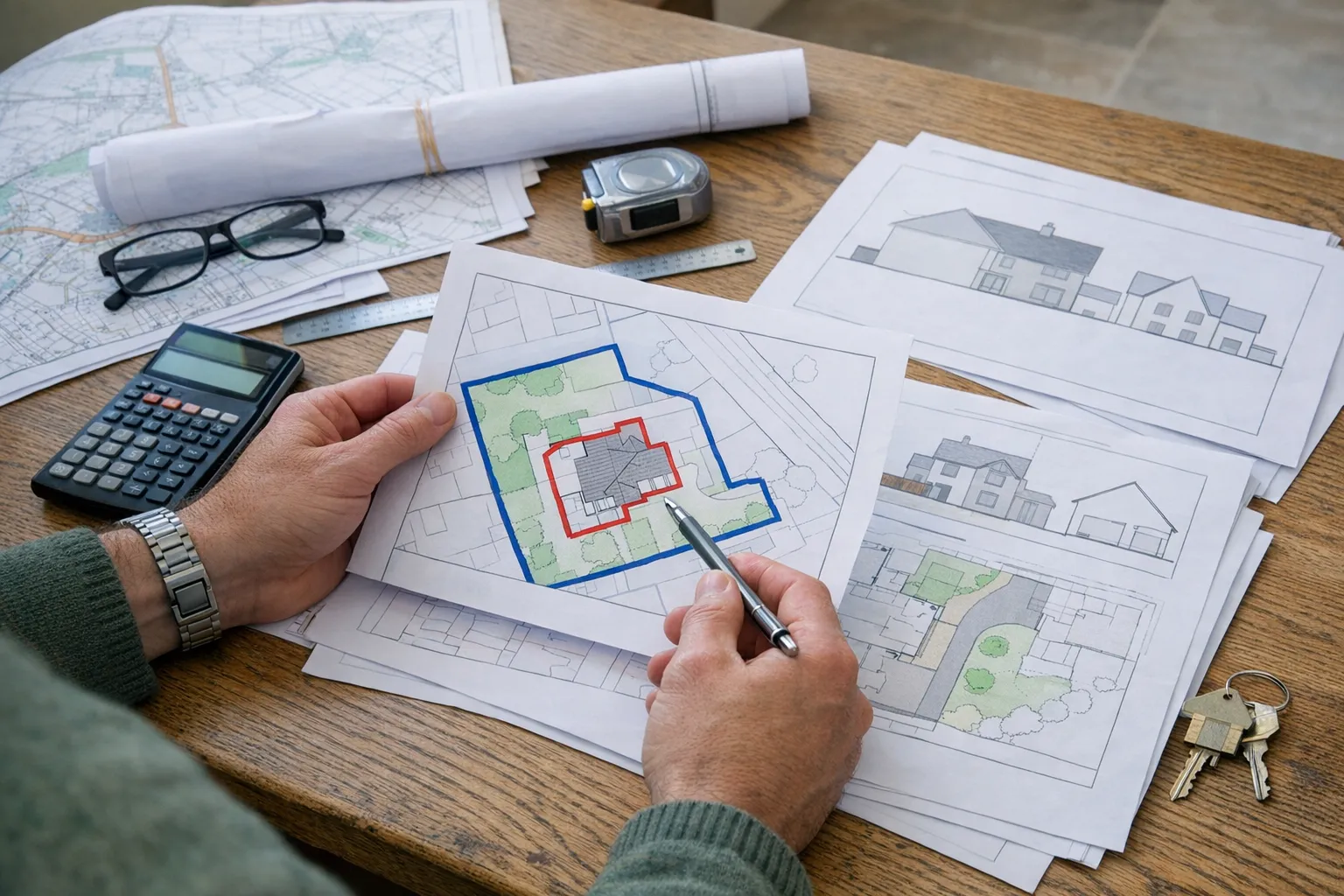
The red line boundary looks simple.
It is just a line around the site. Most homeowners assume they can draw it in a minute.
Then the questions start.
Do you include the whole garden? What about the driveway? What if the extension is at the back but access is at the front? What if the side path is shared? What if you own another strip of land next door?
For a home extension, the red line is one of the most important parts of the site location plan. If it is wrong, the application can be delayed, returned, or made more complicated than it needs to be.
This guide explains how to think about the red line for extensions in plain English.
Learn how to think about the red line boundary for a home extension, including gardens, driveways, access, blue lines, and common homeowner mistakes.
What the red line actually means
The red line identifies the application site.
It tells the council which land is included in the planning application. It is not only a drawing aid. It defines the land the application relates to.
For an extension, the red line appears on the location plan and may also be shown on the block plan. It should be clear, continuous, and consistent.
The key phrase to remember is this:
The red line should include the land necessary to carry out the proposed development.
That often means more than the extension footprint.
For a broader homeowner overview before you get into extension-specific details, read the red line boundary rule explained guide.
Do not draw only around the new extension
This is the classic homeowner mistake.
You are building a rear kitchen extension, so you draw a red line tightly around the proposed new kitchen. It feels efficient. It feels focused.
But it usually does not work.
The council needs to understand the extension in relation to the property, garden, access, and boundaries. A tiny red box around the new footprint does not show the application site properly.
For a normal householder application, the red line usually follows the full planning unit. That typically means:
- The house
- The garden
- The driveway
- Side paths or access routes
- Outbuildings within the site
- Land needed to carry out the works
The proposal is the extension. The application site is usually the property.
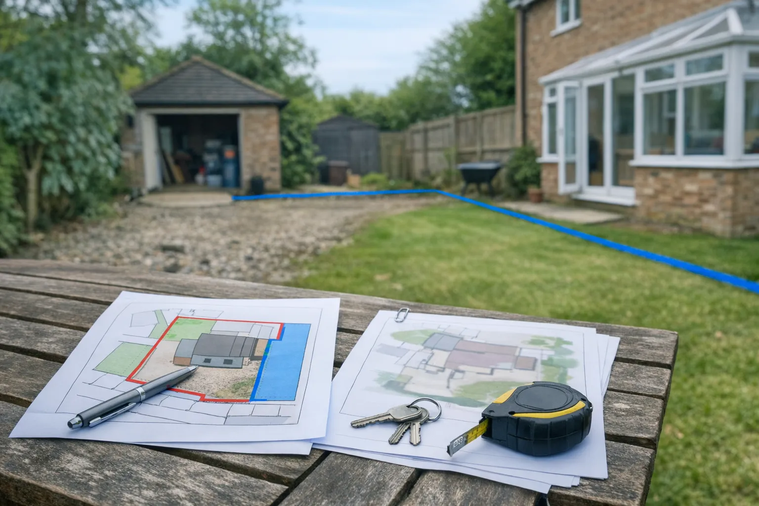
Include the garden when it forms part of the site
Rear extensions, side extensions, and wraparound extensions all affect how the house relates to the garden.
The council may need to consider:
- Garden depth after the extension
- Distance to boundaries
- Relationship to neighbouring plots
- Access around the property
- Existing outbuildings or hardstanding
If the garden is cropped out, that context disappears.
A simple example: a homeowner proposes a modest rear extension. On paper, the extension looks fine. But the garden is shallow, and the extension would leave very little outdoor space. If the red line and block plan do not show the garden clearly, the application does not tell the full planning story.
That is why the garden is normally included.
Remember the driveway and access
Access can feel unrelated to a rear extension, but it still matters.
The site must connect to the public highway. If the house fronts the road, this may be obvious. If the property has a private driveway, shared lane, rear access, or unusual layout, the map needs more care.
For example:
- A detached house set back from the road may need the driveway included.
- A house reached by a shared private lane may need the access route shown.
- A corner plot may need the correct road relationship visible.
- A rear extension served by side access may need the side route shown clearly on the block plan.
If access crosses land you do not own, do not guess the paperwork. The red line and ownership certificates must be considered together.
When to use a blue line.
When to use a blue line
The blue line is for other nearby land owned by the applicant but not included in the application site.
It is not a backup red line. It is not used to show land you wish you owned. It is not there to make the map look official.
For example, suppose you own the house you are extending and also own a separate garage plot nearby. If that garage plot is not part of the extension application but is close to the site, it may need to be shown in blue.
Many simple householder applications do not need a blue line at all.
If you do use one, make sure it has a reason.
Keep the red line identical across maps
The red line on the location plan and the boundary on the block plan should tell the same story.
They may appear at different scales, but they should not describe different sites.
Before submitting, compare:
- Your 1:1250 location plan
- Your 1:500 or 1:200 block plan
- Your proposed site plan or architectural drawing
- Your application form and ownership certificate
If one document shows the whole property and another shows only the extension footprint, fix that before submission.
Inconsistent boundaries create avoidable doubt. Doubt creates delay.
What if the fence is not the legal boundary?
Many homeowners treat the fence line as the boundary.
Often that is a reasonable starting point. But it is not always legally perfect. Fences move. Old walls come down. Neighbours replace panels. Title plans are general boundaries, not precise survey drawings.
For most straightforward extensions, the practical aim is to mark the application site clearly and honestly using the best available information. If there is a known boundary dispute, unusual ownership issue, or shared access, get advice before submitting.
Planning maps help present the site. They do not settle boundary disputes.
A quick red-line checklist for extensions
Before you upload your planning maps, ask:
- Does the red line show the whole application site?
- Have I avoided drawing only around the extension footprint?
- Is the garden included where it forms part of the planning unit?
- Is the driveway or access route included where relevant?
- Is any other nearby owned land shown with a blue line if needed?
- Does the red line match across every map?
- Would a planning officer understand the site without calling me?
If the answer to the last question is no, the map probably needs improving.

The easiest way to avoid red-line problems.
The easiest way to avoid red-line problems
Start with proper Ordnance Survey planning maps. Use the location plan for wider context and the block plan for the detailed site relationship.
Then mark the boundary once, carefully, and keep it consistent.
The red line is not the most exciting part of an extension. But it is one of the first things a council sees.
Get it right, and the application can move on to the real question: whether the extension itself is acceptable.