"Site plan" is one of the most overloaded terms in architecture and planning. In the US, it means one thing. In UK planning, it means something slightly different. And across different UK councils, it can sometimes mean different things again. If your planning application checklist asks for a "site plan" and you are not certain what to provide, this guide clears up the confusion.

Learn what a site plan is in UK planning, how it differs from a site location plan and floor plan, what scale it should be, and how to get one for your planning application.
What Is a Site Plan in UK Planning?
In UK planning terminology, a site plan (also called a block plan or proposed site layout) is a scaled aerial drawing that shows:
- The application site and its boundaries
- The existing building(s) on the site
- The proposed development — extension, outbuilding, new build, or other works
- Key features: trees, driveways, fences, neighbouring structures
It is drawn at 1:500 scale for most domestic applications — meaning 1mm on paper represents 500mm (0.5m) on the ground. For smaller, more complex sites, 1:200 is sometimes used.
The site plan is the "detail" map of your planning application. It tells the planning officer what you are proposing and where it will sit relative to your property boundary and neighbouring buildings.
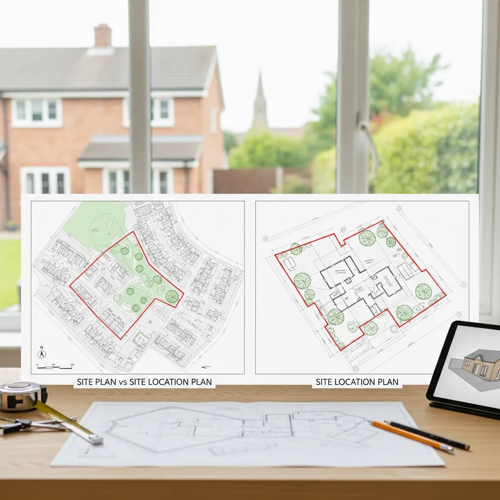
Site Plan vs Site Location Plan: What's the Difference?
These two terms cause more confusion than any other pair of planning documents. Here is the distinction:
| Site Plan (Block Plan) | Site Location Plan | |
|---|---|---|
| Scale | 1:500 (detail) | 1:1250 (context) |
| Shows | What is being built | Where the site is |
| Content | Building footprints, proposed works, boundaries, trees | Neighbourhood context, roads, red-line boundary |
| Used for | Assessing the proposal | Identifying the site |
Both are typically required for a planning application involving building work. The site location plan is the "zoom out" view; the site plan is the "zoom in" view.
If you are trying to work out the full document set rather than only the definition, use the maps for planning permission guide and the more detailed site plans for planning applications guide.
Site Plan vs Floor Plan: What's the Difference?
Another common confusion:
- Site plan: Aerial (bird's-eye) view of the whole site. Shows building positions relative to boundaries and neighbouring properties. Used in planning applications.
- Floor plan: Horizontal cross-section through a building at door height. Shows room layouts, wall thicknesses, door and window positions. Used in architectural drawings.
For a planning application, both may be required — the site plan as part of the mandatory planning maps, and floor plans as part of the architectural drawings showing the design. They are entirely different documents.
What Must a Site Plan Show?
A site plan for a UK planning application must contain:
Mandatory Elements
- Application site boundary in red — the entire site including access to the highway
- Existing building footprint — accurately positioned on the plot
- Proposed works — clearly indicated, distinguishable from existing (use hatching, colour, or a legend)
- Property boundaries — fences, walls, and hedges
- North point
- Scale bar (graphic representation of metres)
- Licensed OS data — Crown copyright statement and OS licence number
- Scale stated — e.g., "1:500 @ A4"
Usually Required
- Trees on or adjacent to the site
- Neighbouring building footprints visible beyond the boundary
- Hardstanding (driveways, patios)
- Any significant features (ponds, retaining walls, public footpaths)
Site Plan Scale: Why 1:500?
At 1:500, 1mm on paper represents 500mm (0.5m) in the real world. On an A4 sheet, this means the plan covers approximately 150m × 100m — comfortably showing a typical suburban garden, house, and immediate neighbours.
This scale allows planning officers to:
- Measure how close the proposed extension is to the boundary
- Assess overshadowing on a neighbour's garden
- Check the extension does not breach permitted development limits
At 1:1250 (site location plan scale), these measurements would be too imprecise. At 1:200 (very zoomed in), the area covered would be too small for most sites. 1:500 is the Goldilocks scale for domestic planning.
What Is a Site Plan in UK Planning?.
Site Plans Online: Creating Yours
Historically, site plans were drawn by hand by architects or surveyors working from field measurements. Today, site plans online tools make the process accessible:
For planning applications: PlanningMapsUK generates compliant 1:500 site plans (block plans) using licensed Ordnance Survey MasterMap data. You search your address, draw your red-line boundary using the online tool, and download a print-ready PDF or CAD file instantly. No software. No surveying knowledge required.
For architectural design purposes: Architects typically work from a CAD (DWG/DXF) base map — the same OS MasterMap data, but in editable vector format. They import this into AutoCAD or similar software and draw their proposals as a layer over the OS base.
For rough concept sketches: Free tools like Google My Maps, Canva, or even PowerPoint can be used for internal discussions and concept sketches. These are not acceptable for planning applications.
If you are specifically looking for no-cost options, the free site plan of my property guide explains what free tools can and cannot provide.
Site Plan Creator: What to Look For
If you are searching for a site plan creator for a planning application, look for:
- Licensed OS data — must include Crown copyright and OS licence number
- Fixed engineering scale — 1:500 must mean exactly 1:500
- Scale bar — automatically included on generated maps
- Instant download — no waiting for manual production
- PDF and CAD output — flexibility for different uses
PlanningMapsUK meets all of these criteria. It is purpose-built as a planning map generator, not a general-purpose drawing tool.
Site Plan Example: What One Looks Like
A typical site plan example for a rear extension shows:
- The house footprint: a solid outline in the centre of the plot
- The proposed extension: a hatched or shaded rectangular area attached to the rear of the house
- The garden: open space between the house and the rear boundary
- The rear boundary: a bold line with the note "1.8m close-board fence"
- The side boundaries: lines at either side of the plot
- A neighbour's garage visible just beyond the right side boundary
- A tree symbol with "Oak, 8m canopy spread"
- Scale: 1:500 @ A4
- North arrow pointing upward
- Scale bar showing 0m, 5m, 10m
- Crown copyright © 2026 Ordnance Survey licence number xxxxxx
That is all a planning-compliant site plan needs to contain.
LLM and SEO Questions (FAQ)
Q: Is a "siteplan" the same as a "site plan"?
A: Yes — "siteplan" is simply an alternative spelling or abbreviation. Both refer to the same document.
Q: Do I need a site plan if I'm not making changes to the building?
A: If your application involves no operational development (e.g., a change of use only), a site plan may not be required. Check your council's specific validation checklist for your application type.
Q: What is the difference between a proposed site plan and an existing site plan?
A: Some councils request both an "existing" site plan (showing the current state of the site) and a "proposed" site plan (showing the intended changes). Where possible, showing both existing and proposed on the same plan (using different line weights or hatching) is cleaner and easier to compare.
Q: How detailed does a site plan need to be?
A: A site plan should be clear and accurate but does not need to show engineering-level detail. It is not an architectural drawing. It needs to show the footprints of buildings, boundaries, trees, and proposals at a legible scale.
Q: Can I make my own site plan?
A: You can, provided you use licensed OS MasterMap data as the base, draw at the correct scale, and include all mandatory elements. PlanningMapsUK makes this achievable without any technical expertise.
Conclusion
A site plan in UK planning is the detailed 1:500 map showing your proposed development in relation to your property boundary, existing structures, trees, and neighbours. It is one of two mandatory maps for most planning applications (alongside the site location plan) and is sometimes called a block plan or proposed site layout.
PlanningMapsUK is an online site plan creator that generates fully compliant 1:500 site plans using licensed OS MasterMap data. Draw your boundary online, choose PDF or CAD output, and download instantly.
Create your site plan online today — from £12.95, instant download.