
UK Planning Maps Guide 2026
Discover exactly what local planning authorities demand from your site location plan in 2026 — and ensure zero validation delays.
A tiny map error can pause your project for weeks.
Roughly 1 in 5 planning applications in the UK are immediately kicked back as "invalid" before an officer even reviews them. The most common culprit? Non-compliant site maps.
Whether it's an incorrect scale, an unlicensed Google Maps screenshot, missing acreage, or a red line drawn without consideration for access roads—mistakes delay works and drive up costs in 2026.
This guide provides the definitive checklist for what your council demands right now to pass validation instantly.
Compliant Planning Map Example
The details to check before you submit
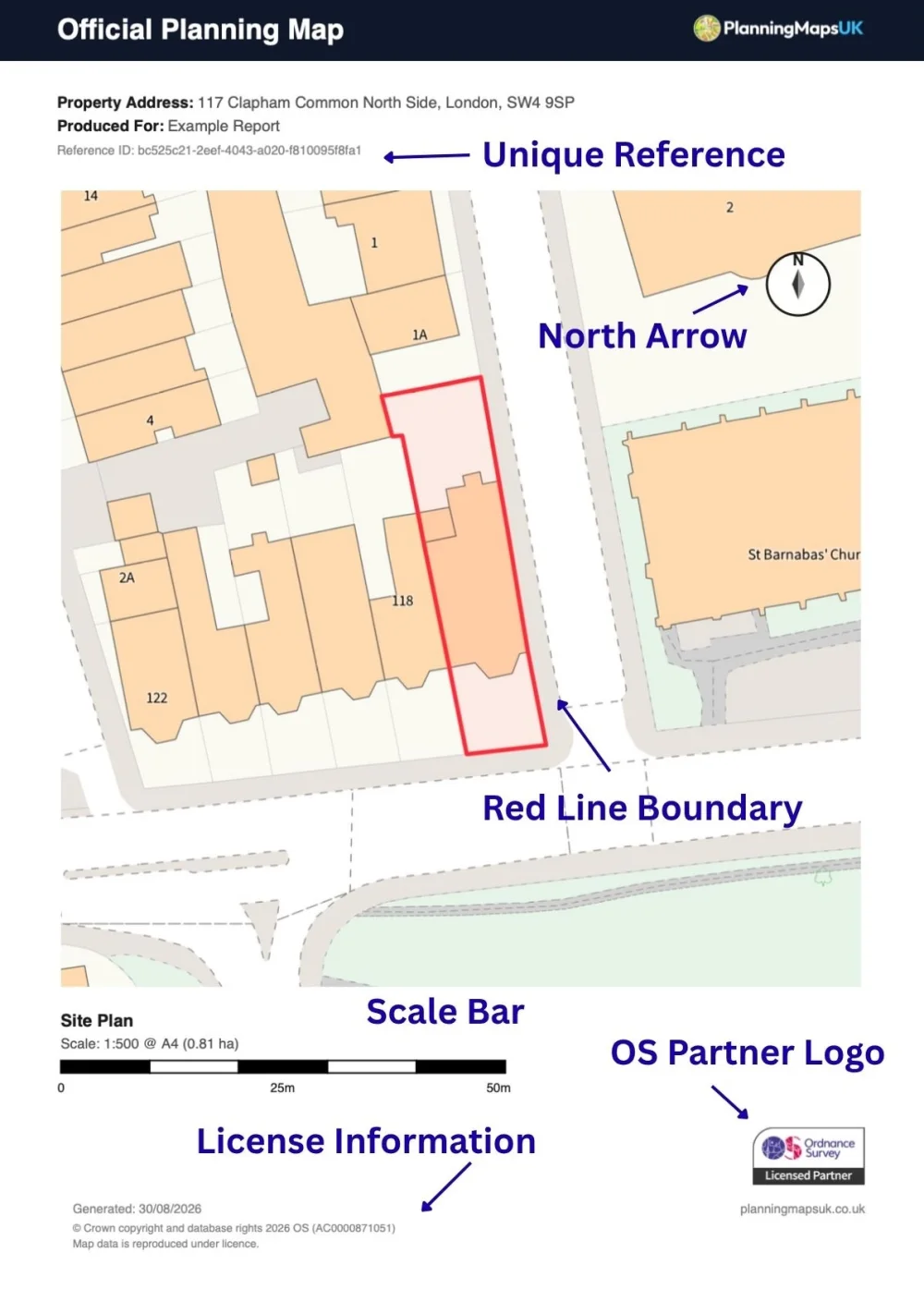
Use this annotated PlanningMapsUK example to identify the red-line boundary, north arrow, scale bar, plan reference and Ordnance Survey licensing information on the finished sheet.
Boundary Logic: Red vs. Blue
Getting the boundary wrong is an immediate fail. Red defines exactly where you are building and needing access. Blue indicates additional land you own.
Required for the primary site and access.
- + Building footprint & garden
- + Driveway & access to highway
- + All land required for scaffolding
Other land owned by you adjacent to the site.
- + Adjacent paddocks or fields
- + Separate owned access ways
- + Plots within ~50m
Scale & Aspect
You must use standardised metric scales that can be measured off a printed sheet.
Urban site location plans
Standard block plan for extensions
Rural/large site location plans
North Arrow
Every valid map requires an unambiguous north orientation to verify solar access and layout.
Road Names
A minimum of two named roads allows officers to instantly correlate your site with the wider geography.
Buildings Context
The surrounding physical environment must be clear. Missing built-context leads to immediate rejection.
Legit OS Licensing
Only properly licensed Ordnance Survey maps containing the exact Crown Copyright attribution are accepted.
The 5 Fatal Flaws in Map Design
The most common pitfalls that will guarantee a swift application rejection from the council.
Google Maps or Apple Maps Screenshots
Neither are licensed for planning purposes. In 2026, councils scan for this rigorously and refuse them instantly.
Broken Scaling (To Fit Paper)
"Scale to fit" on your PDF viewer will warp the true 1:1250 or 1:500 ratio. When authorities measure digitally, the dimensions won't line up.
Unconnected Access Strips
Failure to draw the red line continuous from the primary dwelling onto the adopted public highway is a guaranteed validation failure.
Stale OS MasterMap Extracts
If your dataset is years old, surrounding developments won't appear on your submission. Planners require the latest topological iterations.
Cropped OS Attribution
Scaling away the copyright notice or license number invalidates the submission from a legal standpoint entirely.
Automate 100% Compliance
With PlanningMapsUK, every map you buy fulfills all planning requirements natively. Auto-scaling, dynamic north arrows, active OS licenses, and pixel-perfect printing definitions.
- ✓Live OS MasterMap Data Engine
- ✓A4/A3 Context Scaling Checks
- ✓PlanningMapsUK correction support
Guide FAQ
Do I need a site location plan AND a block plan?
Yes. Under standard 2026 regulations, householder and full applications mandate both. A 1:1250 location plan positions you in the broader community geography, while the 1:500 block plan details precise developmental interventions.
Can I just print it at home on A4?
You can, as long as you print at "Actual Size" or 100%. If your printer applies any "Scale to Fit" configuration, the map's 1:1250 scale breaks, leading to rejection.
Is a Land Registry title plan suitable?
Never. Title plans lack necessary detailing, active licenses, precise OS scaling, and sufficient contextual surrounding bounds to evaluate developmental impact effectively.
What correction support do I have with PlanningMapsUK?
If your application is invalidated purely due to a PlanningMapsUK map-preparation or compliance error, our acceptance guarantee covers review and replacement of the affected map free of charge.