ArborLayerby PlanningMapsUK

Individual
tree map
of Britain.

A British tree map dataset for planning and GIS. Detailed geospatial data of modelled tree locations, heights and canopy extents. Available as location, block, site plans, GIS tile extracts, or full datasets. Custom file formats available upon request.

Interactive illustration of a tree mapping datasetAn isometric landscape with buildings and selectable trees. Switch between canopy, height and point views. Geometry and measurements are illustrative.N
T08 IDHeight 18 mRadius 7.7 m
British tree map: modelled locations, heights and canopy outlinesDiscover ArborLayer

Tree Mapping for England

Geospatial tree map data
Perfect for geospatial GIS solutions or simple planning maps

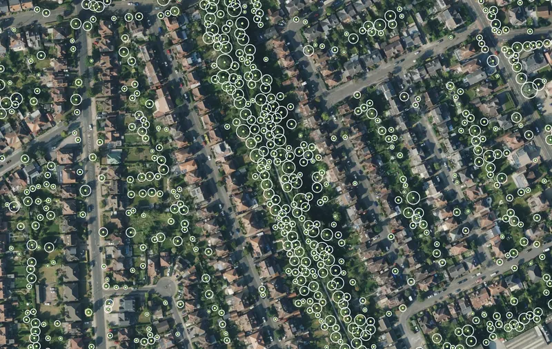
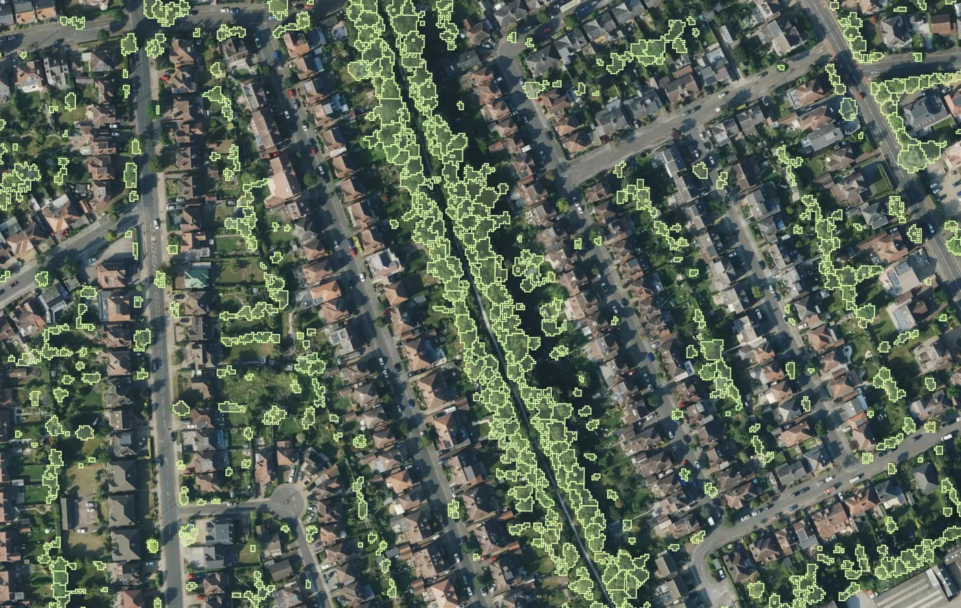
ArborLayer turns open source geospatial data into a practical view of individual tree locations, heights and canopy sizes in the form of exact canopy polygons and radius crowns. Explore the results as an interactive layer, inspect individual features and add editable, labelled trees to your planning drawings or GIS workflow.

How ArborLayer is built: We built a custom mapping pipeline that analyses open LiDAR point clouds for height, vegetation structure, point density and laser-return patterns. Our algorithms and machine-learning models combine those signals with LiDAR surface and terrain models, derived vegetation objects, satellite imagery and building footprints to separate likely trees from buildings and other above-ground features.

Human-reviewed samples help us spot false positives and improve the models over time. Each mapped feature includes its source date, giving planning and property professionals useful early-stage context while making the age of the underlying data clear.

ArborLayer is in its pilot data phase. We are continually striving to improve the quality and accuracy of locations, heights and canopies where individual tree identification is challenging, and individual trees can be missed, merged or incorrectly identified. Use ArborLayer to inform early decisions, prior to full and formal tree surveys being commissioned.

LocationsModelled tree centre points
HeightsEstimated vertical tree heights
CanopiesCrown outlines & canopy cover
RadiiIdealised circular canopy extents
Source datesSurvey & data provenance

What’s included in the dataset

Tree Map
of Great Britain

Each mapped feature includes modelled dimensions and source information. Select an attribute below to see what it represents.

Tree locations

Each likely tree has a modelled centre point, making it easy to query individual features and connect their geometry to other spatial data across your site.

Locate and query modelled tree positions
An example tree
Tree centre
Illustrative canopy and measurements

Applications & Sectors

From individual sites
to wider landscapes.

Practical tree context for planners, architects, surveyors, GIS analysts and researchers. Choose your area of work below.

Explore tree cover and assess site constraints.

Explore likely tree cover when assessing sites, layouts and potential constraints. Identify possible design conflicts early and prepare more effectively for a formal tree survey.

  • Early-stage feasibility and site layout appraisals
  • Preliminary screening of tree constraints against layouts
  • Desktop preparation before commissioning BS5837 surveys
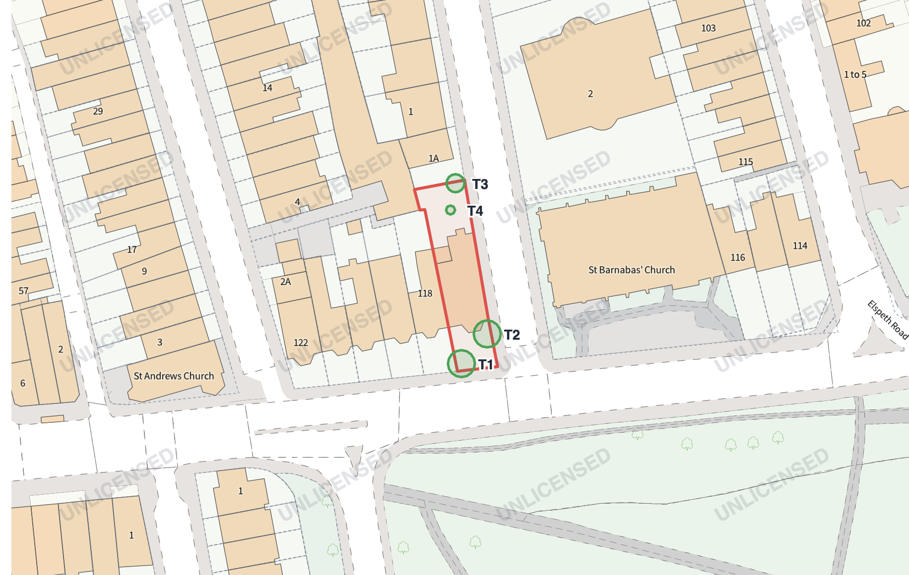
Trees on a PlanningMapsUK drawing
PlanningMapsUK drawing example with a red site boundary and editable labelled green tree canopy symbols
PlanningMapsUK drawing editor

Planning Drawing Workflow

Add tree mapping data
to your workflow

ArborLayer connects our modelled tree data directly to your GIS workflow or purchase tiles from our mapshop. Inspect mapped features, view their estimated dimensions and place labelled canopy symbols onto your planning application drawings.

  1. 01
    Inspect the tree map

    View modelled canopy outlines, estimated heights and source dates within your site boundary.

  2. 02
    Place editable symbols

    Convert mapped features into labelled, editable canopy symbols with height and radius callouts.

  3. 03
    Export compliant plans

    Download scaled, planning-ready PDF, CAD DXF or image plans with tree context in place.

Create a site plan with manual tree symbols Enquire about modelled tree data and coverage. Automatic tree-data checkout is coming soon; manual tree drawing is available now.

Coverage & Provenance

Mapping trees
in all of Britain

ArborLayer coverage is expanding across England, Wales & Scotland. Every feature includes date-stamped metadata so you can check the age of the underlying LiDAR survey for your site. We’re working on improving quality all the time across all of Britain to improve accuracy from our pilot data.

Check coverage for your area
ArborLayer tree data

Where do you need tree map data?

Choose a 1-hectare site plan add-on, a 1 km² or 4 km² GIS extract, or talk to us about data for a larger site, corridor or region.

Geographic coverage
Expanding across England
Data sources
Open LiDAR, Sentinel-2 & building footprints
Feature attributes
Estimated height, canopy, centre, radius, date
GIS formats
GeoJSON · Shapefile · DXF · PMTiles
Purchasing options
Site plan add-on · GIS extracts · Larger datasets

Delivery & Usage

Three ways to
use ArborLayer.

Buy a small site from the mapshop, host a licensed dataset in your own GIS, or stream tiles through a custom API built for your organisation.

Mapshop

Buy a small area for a planning application.

Use our location, block and site plan tooling to add ArborLayer trees to a defined site. Built for planning drawings where you need a scaled plan, not a full GIS dataset.

  • Location, block and site plans from the mapshop
  • Typical site area up to 1 hectare
  • Inspect trees, then export PDF, DXF or image plans
Create a site plan

Self-hosted GIS

License the data for your own software.

Receive ArborLayer as files you host and use inside commercial GIS workflows, or under education and charity licensing. Work in QGIS, ArcGIS, CAD or your own stack.

  • GeoJSON, Shapefile, DXF and PMTiles
  • Commercial, education and charity licences
  • Extracts through to regional or national datasets
Enquire about licensing

Custom API

Stream tiles through an API we build for you.

We can build a custom API so your organisation can request ArborLayer tile by tile and stream it into applications, portals or mapping services.

  • Tile-by-tile requests on demand
  • Designed around your systems and access rules
  • Suitable for products, portals and internal tools
Talk to us about an API

Pricing & Licensing

Buy tile by tile
Or license a custom or whole dataset.

Add ArborLayer data to a 1-hectare site plan, buy a 1 km² or 4 km² GIS extract, or ask us about licensing data for a larger area.

In PlanningMapsUK

Add tree data
to your plan.

£12.95

Per plan · site area up to 1 hectare

Enquire about adding modelled tree data to your PlanningMapsUK order. Inspect height and canopy estimates, then bring editable canopy symbols onto your site plan.

  • Interactive tree layer over OS master mapping
  • Modelled heights, canopy outlines & source dates
  • Editable, labelled canopy symbols on your drawing
  • Ask about formats and availability for your site
Enquire about the site add-on Need to draw trees manually? Free tree annotation tool

For your own GIS

Buy an extract
or larger dataset.

1 km² GIS extract£29.95
4 km² GIS extract£79
Larger-area datasetCustom quote

Modelled tree features and attributes for GIS and CAD workflows, supplied as defined-area extracts or larger datasets with project licensing.

  • Standard formats: GeoJSON, Shapefile, DXF, PMTiles
  • Modelled attributes: canopy polygons, heights, radii, dates
  • Larger sites, corridors and regional extracts on request
Enquire about dataset licensing

Tell us your area of interest and format requirements. We’ll confirm current coverage and provide suitable licensing terms.

Frequently Asked Questions

Clear answers
about the dataset.

Coverage, formats, licensing and practical limits of modelled tree data.

What is the ArborLayer tree map?

ArborLayer is PlanningMapsUK’s modelled tree mapping dataset. It provides likely tree locations, estimated heights, modelled canopy outlines and source dates for planning, architecture and GIS work. Coverage is expanding across England.

How can I buy or access the tree map?

Enquire about the planned site add-on (£12.95 for up to 1 ha), as a GIS extract (£29.95 for 1 km² or £79 for 4 km²), or by asking us about a larger-area dataset for GIS and research use.

How is this different from your tree drawing tool?

Our tree drawing tool lets you place and label tree symbols manually. ArborLayer uses our custom algorithms and machine-learning models to derive likely tree positions, estimated heights and modelled canopy dimensions from open geospatial data before you begin drawing.

Which GIS formats are available for the tree map?

ArborLayer tree map data can be supplied in standard GIS formats including GeoJSON, Shapefile, DXF (for CAD workflows), and PMTiles for web mapping. We can output data in British National Grid (EPSG:27700) or WGS84 coordinates.

Can I license data for a larger area or region?

Yes. We provide commercial and academic licensing for larger sites, corridors and regional extracts where coverage is available. Contact us with your area of interest and intended use to receive sample data and licensing terms.

What accuracy can I expect from this tree map?

ArborLayer features are automated estimates, not surveyed measurements. Coverage and source dates vary, and trees can be missed, merged or incorrectly identified. Source dates are attached to mapped features so you can check the age of the underlying data. ArborLayer is useful for early-stage planning and desktop analysis, but it does not replace a professional tree survey.

Does this tree map replace a BS5837 tree survey or show TPOs?

No. ArborLayer provides modelled canopy extents, estimated heights and likely locations; it does not provide surveyed trunk positions, identify species, assess tree health or record Tree Preservation Orders (TPOs). Use it for initial site appraisal and layout planning before a detailed ground survey.

Need modelled tree data
for your project?

Enquire about ArborLayer

British Tree Mapping · Expanding England Coverage · Planning · Architecture · Infrastructure · Environment · GIS Research