
Tree Preservation Orders (TPOs) & Section 211
Applying to work on protected trees or giving 6 weeks’ notice in a Conservation Area requires a clear plan identifying each tree (T1, T2...) and its crown spread relative to property boundaries.
Add trees directly to licensed Ordnance Survey planning maps. Set real crown radius in metres, label stems T1, T2, T3, and download council-ready site and block plans for planning applications, TPOs, and Conservation Areas.
Search by postcode or address
Search any UK address to open licensed OS mapping with the tree tool ready.
1:500 block plan preview
Oak Cottage · RG4 8QJ
T1 · 6m canopy diameter (3.0m radius)
AdjustableCouncil validation ready
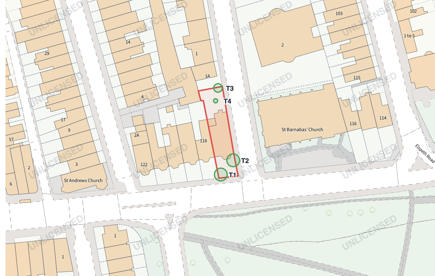
Council validation teams reject applications with vague sketches or missing crown spreads. This is how tree annotations appear on your finished Ordnance Survey plan:
Where this is required
Whenever a proposal sits near trees or hedges, councils require their positions and crown spreads to be clearly identified on an accurate metric map.
Applying to work on protected trees or giving 6 weeks’ notice in a Conservation Area requires a clear plan identifying each tree (T1, T2...) and its crown spread relative to property boundaries.
Question 15 on planning applications asks if trees could influence development. Planners need to see whether proposed footings, rooflines, or scaffolding encroach under tree canopies.
Highways authorities and council tree officers check whether new driveways or dropped kerbs clash with root protection zones or canopies of roadside verge trees.
Identify potential root clashes early before pouring foundations, digging drainage runs, or erecting scaffolding near mature garden trees.
How it works
Plot trees straight onto licensed Ordnance Survey mapping in your browser. No CAD experience, manual tracing, or complex software needed.
Open the plan editorEnter a postcode or address to load up-to-date, licensed Ordnance Survey MasterMap data centred on your site.
Outline your red-line application site boundary, and add blue lines for any adjoining land you own.
Click to position stems with automatic T1, T2, T3 labels. Enter crown radius in metres or drag handles to scale.
Export a scaled 1:200, 1:500, or 1:1250 PDF with north arrow, scale bar, and licensed OS copyright ready for submission.
Who uses this
Whether you are submitting your own planning application or preparing client drawings, our tree tool saves hours of drafting time and avoids validation delays.
Satisfy council validation checklists for rear extensions, garden studios, and driveway alterations without paying hundreds for specialist CAD drawings.
Quickly mark site constraints and tree canopies on early feasibility layouts and pre-application submissions before commissioning full topographical surveys.
Produce clean, professional sketch plans to accompany Section 211 Conservation Area notices and formal TPO work applications for your clients.
Plot boundary trees, hedgerows, and potential root zones across infill plots, barn conversions, and access tracks.
Accurate planning annotations
Tree positions don’t float as detached graphics—they are anchored directly to your scaled Ordnance Survey map data.
Sequential numbering ensures your map references match your planning application forms, tree works descriptions, and arboricultural schedules exactly.
Set crown radius from 0.5m up to 50m. Canopies render to exact scale at 1:200, 1:500, or 1:1250, showing true proximity to proposed walls and boundaries.
Tree canopies sit cleanly alongside your red-line site boundary and existing building footprints, maintaining full geographic alignment.
Important planning guidance: This tool produces scaled site layout and block plans showing tree locations and canopy spreads for planning submissions, TPOs, and conservation area notifications. Where an LPA specifically conditions a formal British Standard BS 5837 tree survey or Arboricultural Impact Assessment (AIA), our OS-based plans serve as the ideal baseline site plan for your registered arboriculturist.
Need the wider planning context too? Pair your tree plan with a 1:1250 site location plan or a detailed 1:500 block plan.
Frequently asked questions
Practical advice on council validation rules, numbering conventions, and scale requirements.
Yes, in most cases. Question 15 on standard UK planning application forms specifically asks whether there are trees or hedges on the site or adjacent land that could influence the development. Local planning authorities typically require a 1:500 or 1:200 block plan showing the stem position and canopy spread of all trees within 15 metres of any proposed groundworks, extensions, or scaffolding.
Standard UK planning and arboricultural convention uses sequential reference numbers: T1, T2, T3 for individual trees; G1, G2 for tree groups; and H1, H2 for hedgerows. These numbers match the descriptions on your planning application forms, tree schedules, or Section 211 notifications.
A 1:500 block plan (or 1:200 for tight urban and terraced plots) is standard for showing tree canopies and their proximity to building footprints and site boundaries. A 1:1250 site location plan is usually submitted alongside it to show the wider neighbourhood context.
Councils require an accurate sketch or OS site plan clearly identifying each protected tree by number, showing its position relative to the property and boundaries, and indicating the proposed works (e.g. T1: fell; T2: 20% crown reduction). In Conservation Areas, you must provide 6 weeks’ notice (Section 211 notice) before pruning or felling any tree with a stem diameter over 75mm.
No. Our tool produces accurate, scaled site and block plans for council validation, pre-planning discussions, and tree work notifications. If your local planning authority explicitly conditions a formal British Standard BS 5837 tree survey, arboricultural impact assessment (AIA), or tree protection plan, an arboriculturist will use this scaled OS plan as the baseline drawing for their report.
Search your address, plot your trees with scaled canopies and T1 labels, and download an official OS planning map in minutes.
Start your tree plan nowInstant download · Official OS MasterMap · Accepted by UK local planning authorities