
What Is a Site Location Plan?
Learn what a site location plan must show, which scale to use, and when councils require one.
Read guideStart with your address

Search your address to see your plan exactly as it will print
Before you order
Check our OS partner profileRead our map corrections promise
 Open the 1:1250 PDF example image ↗
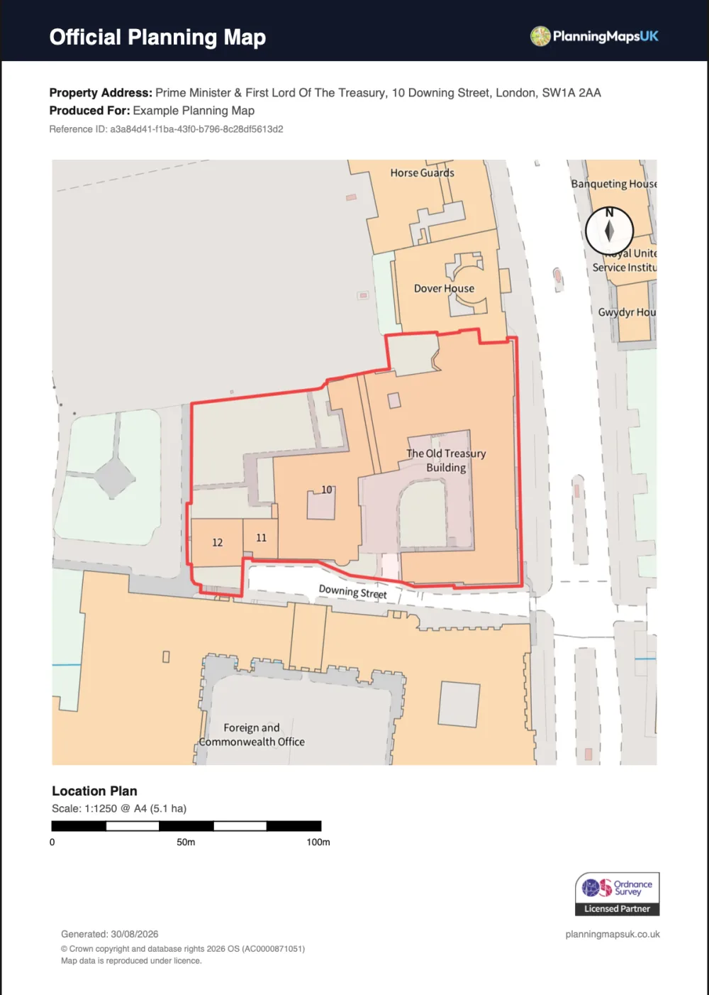
Site Location Plan Example
This 1:1250 example shows the wider road and building context, red-line application boundary, north point, scale bar and licensed Ordnance Survey details used in a planning submission.
Want to compare the available A4 coverage areas first? See the 1:1250 location plan samples.
A site location plan is the wider-context map councils use to find the land. Search an address in England, Scotland or Wales, draw the red line on licensed OS MasterMap, and download a 1:1250 PDF. Pair it with a 1:500 block plan when the local list also wants site detail, or use Boundary Finder if you need a general-boundary report first.
Search, preview, and download your planning maps in under 60 seconds. No waiting for quotes.
Our workflow checks your location plans for planning applications against standard planning-map presentation requirements.
Order this drawing when the authority must see where the proposal sits, not how the buildings are arranged. That is the usual first map for householder planning, prior approval, lawful development certificates, listed-building applications and many full applications. If the local list only says “location plan”, this is the product — not a 1:500 layout.
National guidance and most local lists describe a location plan as a metric OS-based map at 1:1250 (or 1:2500 in the countryside), with the application site edged in red and enough surrounding context for an officer who has never visited. Access to the public highway belongs inside the red line even when the works themselves are at the rear of the plot.
Use 1:1250 for most urban and suburban houses. Switch to 1:2500 when a 1:1250 sheet cannot show enough neighbouring roads, which is common on rural lanes and larger plots. Broader 1:5000 and 1:10000 options exist for estates and unusual sites. A 1:500 or 1:200 sheet is a block plan, not a location plan.
Validation teams fail location plans for context and identification errors, not for missing parking bays. Fix these before you upload to the Planning Portal.
Keep this page for the context map. Add a block plan when the council also wants buildings, boundaries, access and the proposal shown at 1:500 or 1:200. Many householder applications need both. Start the location plan here, then order the matching closer sheet from the block-plan builder so the red line is consistent.
A location plan fails when the officer cannot identify the site, cannot see the access, or cannot see a licensed OS sheet. These checks are specific to the 1:1250 context map.
The red line must sit in enough surrounding OS context — neighbouring plots and named roads or identifiable landmarks — that someone who has never visited can find the land. That is the job of a location plan, not a close site layout.
The application site includes all land needed to carry out the development. On a location plan that almost always means the garden and the access out to the public highway, even for a rear extension.
The sheet must be a current Ordnance Survey location plan at the metric scale the local list names, with a north point, scale bar and licence acknowledgement. A 1:500 block plan or a web-map screenshot will not substitute.
1:1250, 1:2500 and broader location-plan coverage on A4 to A1. These prices are for identifying the site in its wider setting — not for a 1:500 block plan.
| Map Type | Scale | Coverage | Area | Price |
|---|---|---|---|---|
| Location Plan | 1:1250 | 141m x 141m | 2 ha | £20.50 |
| Location Plan | 1:1250 | 173m x 173m | 3 ha | £27.95 |
| Location Plan | 1:1250 | 200m x 200m | 4 ha | £33.95 |
| Location Plan | 1:1250 | 225m x 225m | 5.1 ha | £39.95 |
| Rural / Estate Plan | 1:2500 | 316m x 316m | 10 ha | £59.95 |
| Rural / Estate Plan | 1:2500 | 387m x 387m | 15 ha | £69.95 |
| Rural / Estate Plan | 1:2500 | 450m x 450m | 20 ha | £79.95 |
| Large Scale Location Plan | 1:5000 | 707m x 707m | 50 ha | £114.95 |
| Large Scale Location Plan | 1:5000 | 866m x 866m | 75 ha | £154.95 |
| Large Scale Location Plan | 1:5000 | 894m x 894m | 80 ha | £212.95 |
| Regional Context Plan | 1:10000 | 1789m x 1789m | 320 ha | £394.95 |
| Map Type | Scale | Coverage | Area | Price |
|---|---|---|---|---|
| Location Plan | 1:1250 | 200m x 120m | 2.4 ha | £20.50 |
| Location Plan | 1:1250 | 210m x 143m | 3 ha | £27.95 |
| Location Plan | 1:1250 | 280m x 143m | 4 ha | £33.95 |
| Location Plan | 1:1250 | 312m x 143m | 4.5 ha | £39.95 |
| Rural / Estate Plan | 1:2500 | 625m x 285m | 17.8 ha | £79.95 |
| Large Scale Location Plan | 1:5000 | 1340m x 570m | 76 ha | £254.95 |
| Regional Context Plan | 1:10000 | 2680m x 1140m | 306 ha | £440.95 |
| Map Type | Scale | Coverage | Area | Price |
|---|---|---|---|---|
| Location Plan | 1:1250 | 316m x 316m | 10 ha | £54.95 |
| Location Plan | 1:1250 | 335m x 335m | 11.2 ha | £74.95 |
| Rural / Estate Plan | 1:2500 | 500m x 500m | 25 ha | £99.95 |
| Large Scale Location Plan | 1:5000 | 707m x 707m | 50 ha | £134.95 |
| Large Scale Location Plan | 1:5000 | 866m x 866m | 75 ha | £174.95 |
| Large Scale Location Plan | 1:5000 | 1000m x 1000m | 100 ha | £209.95 |
| Large Scale Location Plan | 1:5000 | 1225m x 1225m | 150 ha | £249.95 |
| Large Scale Location Plan | 1:5000 | 1323m x 1323m | 175 ha | £279.95 |
| Large Scale Location Plan | 1:5000 | 1342m x 1342m | 180 ha | £294.95 |
| Regional Context Plan | 1:10000 | 2683m x 2683m | 720 ha | £549.95 |
| Map Type | Scale | Coverage | Area | Price |
|---|---|---|---|---|
| Location Plan | 1:1250 | 400m x 250m | 10 ha | £54.95 |
| Location Plan | 1:1250 | 475m x 250m | 11.9 ha | £74.95 |
| Rural / Estate Plan | 1:2500 | 625m x 400m | 25 ha | £99.95 |
| Large Scale Location Plan | 1:5000 | 1950m x 1000m | 195 ha | £334.95 |
| Regional Context Plan | 1:10000 | 3900m x 2000m | 780 ha | £674.95 |
| Map Type | Scale | Coverage | Area | Price |
|---|---|---|---|---|
| Location Plan | 1:1250 | 316m x 316m | 10 ha | £84.00 |
| Location Plan | 1:1250 | 500m x 500m | 25 ha | £134.00 |
| Rural / Estate Plan | 1:2500 | 707m x 707m | 50 ha | £154.00 |
| Rural / Estate Plan | 1:2500 | 866m x 866m | 75 ha | £164.00 |
| Rural / Estate Plan | 1:2500 | 1000m x 1000m | 100 ha | £174.00 |
| Large Scale Location Plan | 1:5000 | 1225m x 1225m | 150 ha | £209.00 |
| Large Scale Location Plan | 1:5000 | 1414m x 1414m | 200 ha | £229.00 |
| Large Scale Location Plan | 1:5000 | 1581m x 1581m | 250 ha | £249.00 |
| Map Type | Scale | Coverage | Area | Price |
|---|---|---|---|---|
| Location Plan | 1:1250 | 400m x 250m | 10 ha | £84.00 |
| Location Plan | 1:1250 | 625m x 400m | 25 ha | £134.00 |
| Rural / Estate Plan | 1:2500 | 1000m x 500m | 50 ha | £154.00 |
| Rural / Estate Plan | 1:2500 | 1250m x 600m | 75 ha | £164.00 |
| Rural / Estate Plan | 1:2500 | 1250m x 800m | 100 ha | £174.00 |
| Large Scale Location Plan | 1:5000 | 1500m x 1000m | 150 ha | £209.00 |
| Large Scale Location Plan | 1:5000 | 2000m x 1000m | 200 ha | £229.00 |
| Large Scale Location Plan | 1:5000 | 2500m x 1000m | 250 ha | £249.00 |
| Map Type | Scale | Coverage | Area | Price |
|---|---|---|---|---|
| Location Plan | 1:1250 | 707m x 707m | 50 ha | £149.00 |
| Rural / Estate Plan | 1:2500 | 866m x 866m | 75 ha | £179.00 |
| Rural / Estate Plan | 1:2500 | 1225m x 1225m | 150 ha | £209.00 |
| Rural / Estate Plan | 1:2500 | 1414m x 1414m | 200 ha | £229.00 |
| Large Scale Location Plan | 1:5000 | 1581m x 1581m | 250 ha | £259.00 |
| Large Scale Location Plan | 1:5000 | 2236m x 2236m | 500 ha | £329.00 |
| Map Type | Scale | Coverage | Area | Price |
|---|---|---|---|---|
| Location Plan | 1:1250 | 1000m x 500m | 50 ha | £149.00 |
| Rural / Estate Plan | 1:2500 | 1250m x 600m | 75 ha | £179.00 |
| Rural / Estate Plan | 1:2500 | 1500m x 1000m | 150 ha | £209.00 |
| Rural / Estate Plan | 1:2500 | 2000m x 1000m | 200 ha | £229.00 |
| Large Scale Location Plan | 1:5000 | 2500m x 1000m | 250 ha | £259.00 |
| Large Scale Location Plan | 1:5000 | 4000m x 1250m | 500 ha | £329.00 |
| Option | Paper Size | Copies | Notes | Price |
|---|---|---|---|---|
| Printed Copy Pack | A4 | 5 colour copies | Single-plan add-on posted to your address | £10.00 |
| Printed Copy Pack | A3 | 5 colour copies | Single-plan add-on posted to your address | £15.00 |
| Bundle Print Pack | A4 | 6 colour copies | Bundle add-on with 3 copies of each plan | £10.00 |
| Option | Term | Includes | Excludes | Price |
|---|---|---|---|---|
| Single PDF Plan Protect | 12 months | Boundary and annotation edits, plan name / produced-for changes, map-view tweaks up to 10%, and PDF re-downloads | No CAD, no new scales, no new paper sizes | £4.95 |
| Bundle Plan Protect | 12 months | One Protect purchase covers all PDF plans in the bundle, plus re-downloads during the active term | No CAD, no new scales, no new paper sizes | £8.95 |
| Map Type | Recommended Plot Scale | Coverage | Area | Price |
|---|---|---|---|---|
| Location Plan | 1:1250 | ~173m × 173m | 3 ha | £59.95 |
| Location Plan | 1:1250 | ~224m × 224m | 5 ha | £67.95 |
| Location Plan | 1:1250 | ~316m × 316m | 10 ha | £129.95 |
| Rural / Estate Plan | 1:2500 | ~447m × 447m | 20 ha | £235.95 |
| Rural / Estate Plan | 1:2500 | ~500m × 500m | 25 ha | £239.95 |
| Large Scale Location Plan | 1:5000 | ~707m × 707m | 50 ha | £339.95 |
| Large Scale Location Plan | 1:5000 | ~1000m × 1000m | 100 ha | £451.95 |
| Regional Context Plan | 1:10000 | ~1225m × 1225m | 150 ha | £563.95 |
| Regional Context Plan | 1:10000 | ~1414m × 1414m | 200 ha | £610.95 |
Includes both DWG and DXF formats. CAD files are supplied in real coordinates, so the scale shown here is a plotting guide rather than a fixed paper-output constraint.
Planning Guides
Learn what a site location plan must show, which scale to use, and when councils require one.
Read guideA practical guide to drawing the red-line boundary correctly on planning maps.
Read guideHow much surrounding context a 1:1250 location plan should show, and when to step up to 1:2500.
Read guideAdd labelled tree canopies to your planning map and show how the landscape relates to the site boundary.
Read guideUse a site location plan to show where the land sits in its wider setting. Add a block plan when the council also needs a detailed 1:500 site layout around the proposal.
Choose this when you need a 1:1250 location plan for planning permission, prior approval, or a lawful development certificate. It shows the site in relation to nearby roads and surrounding plots.
Create 1:1250 site location planChoose this when you also need a 1:500 site plan showing boundaries, access, buildings, and the detailed layout around your proposal footprint.
Create 1:500 block planIf a planning authority flags a PlanningMapsUK map-preparation or compliance fault, we will review it and correct the affected map free of charge.
If the issue is caused by our map output:
A site location plan is the wider-context map that identifies the application site. Councils use the 1:1250 (or 1:2500 rural) sheet to see where the land sits against named roads and surrounding plots before they look at any detailed layout.
Most urban and suburban applications use 1:1250. Larger rural sites often need 1:2500 so enough surrounding roads stay on the sheet. This page sells those location-plan scales, not a 1:500 block plan.
A continuous red line around all land needed for the development, including gardens and access to the public highway; a north point; a scale bar; two named roads where possible, or one named road and an identifiable landmark; and licensed Ordnance Survey acknowledgement. Other land you own adjoining the site is edged blue.
Add a 1:500 or 1:200 block plan when the council wants the detailed site layout: buildings, parking, access and the proposal footprint. The location plan does not replace that closer drawing.
Yes. An LDC or other permitted-development confirmation usually needs the same 1:1250 location plan as a full planning application so the authority can identify the property.
Typical location-plan failures are a red line that stops short of the highway, too little surrounding context, unnamed roads, an unlicensed screenshot, or submitting a 1:500 site layout when the local list asked for a 1:1250 location plan.
Authorities require an up-to-date map. Our location plans are generated from current OS MasterMap data at the point of order.
A council-ready PDF of this location plan, with optional DWG/DXF if you need the same OS extract in CAD. Printed copies can be added at checkout.
Search the address, mark the red-line site, and download a licensed location plan for planning, LDCs and prior approval.